


On January 6, 1912, the United States welcomed the 47th state — New Mexico.
It was a long and arduous path to statehood. New Mexico was added to the United States as a territory in 1850. Residents began petitioning for full-fledged statehood shortly thereafter, but conflicts blocked the way. Conflicts between:
- Northern and Southern states.
- English-speaking and Spanish-speaking peoples.
- The establishment of law and order vs. self-rule.
- Industrialization and farming.
After years of debate, President William Howard Taft was instrumental in encouraging Congress to approve admission of the state.
History
The history of New Mexico starts with the history of the Pueblo culture. The Pueblo were a peaceful agrarian people who practiced forms of irrigation considered exceptionally advanced for their time.
The next arrivals on the scene were the more nomadic Navajo and Apache, who are believed to have come from the north sometime in the 1400s.
The Spaniards showed up in 1540, led by Francisco Vásquez de Coronado in a quest of gold. The Spaniards were the ones who gave New Mexico its name (Nuevo Mexico), applying the term to the land of the upper Rio Grande in general. Like the Pueblo, the early Spanish settlers practiced irrigation, but a sheep- and horse-ranching culture also emerged and soon dominated the landscape.
In 1820, William Becknell pioneered the Santa Fe Trail to connect frontier Missouri with the city of Santa Fe, and soon a bustling commercial route was in operation. Santa Fe hosted a population that was hungry for trade with the United States.
In 1846, the Mexican–American War broke out. New Mexico was captured by General Stephen Kearny. All residents were granted amnesty and U.S. citizenship provided they would take an oath of allegiance. New Mexico Territory was duly established in 1850. The southwestern corner, or Bootheel, was later acquired in the Gadsden Purchase of 1853.
New Mexico came into prominence during the era of transcontinental railroad building. The mountains surrounding Santa Fe made the city difficult to access. The Atchison, Topeka & Santa Fe Railroad used the name of the town for marketing purposes, but bypassed it in favor of Albuquerque in 1880. When the railroad did arrive in New Mexico, it brought with it the first major influx of American settlers.
In more recent years, New Mexico’s development has been characterized by urbanization and the rise of service industries.
Geography

New Mexico boasts of 121,697 square miles of incredibly diverse landscape. It is bounded on the east by Texas and the tip of the Oklahoma Panhandle, and it borders Mexico on the south. New Mexico is one of the Four Corners states, sharing its northwestern corner with Colorado, Utah, and Arizona.
The northern part of New Mexico tends to be mountainous and forested, while the southern part boasts the Chihuahuan Desert.
There are almost no natural water sources in New Mexico. The most important rivers are the Rio Grande, Pecos, Canadian, San Juan, and Gila.
Another geographical peculiarity of New Mexico is White Sands, 275 square miles of gypsum crystals piled in dunes over the desert. Most of this area is located within the White Sands Missile Range, with the remainder being available to the public at White Sands National Monument (when missile tests are not being conducted).
The largest city in New Mexico is Albuquerque. This city is an amazing cultural and historical crossroads, featuring everything from ancient native petroglyphs to old Spanish missions, all highlighted by spectacular scenery. Albuquerque is also the Hot Air Balloon Capital of America, serving as home to over 300 hot air balloons.
The capital and key tourist destination of New Mexico is Santa Fe. This city is 7,000 feet above sea level, the highest state capital in the country. Santa Fe is also the oldest state capital, having been founded under Spanish rule in 1610. It is legendary for its beauty, history, culture, and cuisine.
Climate
New Mexico is largely arid to semi-arid with an average annual rainfall of 13 inches. The southwestern part of the state is the driest, some areas receiving as little as eight inches of precipitation per year. Precipitation tends to increase at higher altitudes, with as much as 40 inches falling on the higher mountains annually.
The temperature swings dramatically in New Mexico, with the lowest temperature ever recorded being -50 degrees Fahrenheit and the highest being 122 degrees. However, these changes are most notable at higher elevations. The annual average temperature is in the mid-50s.
The city of Albuquerque boasts 310 sunny days per year.
Flora and Fauna

New Mexico is home to diverse plant and animal species that vary with elevation.
Cacti and creosote bushes are common at lower elevations. The plains and foothills favor prairie grasses, piñon pines, and juniper shrubs. Mountains are home to juniper, pine (particularly ponderosa), aspen, and spruce-fir forests. The very highest peaks have relatively little vegetation.
Jackrabbits, antelopes, and coyotes characterize the lower elevations, while the mountains are home to many large mammals, including mule deer, bighorn sheep, black bears, and mountain lions. Endangered species found in New Mexico include the least tern, the long-nosed bat, and the Mexican gray wolf.
Below the northern part of the Chihuahuan Desert is Carlsbad Caverns. Carlsbad Caverns host 17 species of bats, as well as what is possibly the world’s largest colony of cliff swallows.
The Gila National Forest includes 3.3 million acres (including the Apache National Forest) in the southwestern part of the state, showcasing semi-desert, open rangeland, hillside forest, and mountainous terrain. This wilderness area boasts several animal species of note, particularly the Gila monster, the Gila woodpecker, the Gila trout, the Gila topminnow, and the Gila genus of western chub. The forest is also a favorite spot to camp and stargaze.
Economy
The leading industry in New Mexico is tourism. Millions of visitors flock to the state annually to see the historic sites, enjoy outdoor recreational opportunities in the mountains, or attend rodeos and festivals, particularly the Albuquerque International Ballooning Fiesta.
About half of the New Mexico economy is based on services, with major industries in New Mexico including healthcare, retail, food service, education, and public administration. One quarter of the economy is driven by federal spending. A good portion of the remainder is based on natural resources such as oil, natural gas, copper, iron, lead, zinc, manganese, molybdenum, potash, and perlite.
Manufacturing is primarily centered around the Albuquerque area. Related industries include food processing, petroleum refining, smelting, electronic components, communications equipment, furniture, and construction materials.
At lower elevations, irrigation-based agriculture is practiced. Milk, sorghum, wheat, hay, onions, and chili peppers are among the most important agricultural products in New Mexico.
Interesting Facts
- Mexico is an Aztec word meaning “place of Mexitli,” Mexitli being an Aztec deity.
- By area, New Mexico is the fifth largest state.
- There are 12 people per square mile in New Mexico, making it the sixth least densely populated state.
- New Mexico is officially bilingual. About a third of the families in New Mexico speak Spanish at home.
- By city ordinance passed in 1957, new buildings in Santa Fe must have a Spanish Territorial or Pueblo style of architecture.
- The city of Roswell is home to the International UFO Museum and Research Center, founded on the site of an alleged alien spaceship crash in 1947.
- The Big Room at Carlsbad Caverns is the largest cave chamber in North America, being roughly 4,000 feet long and 625 feet wide. It is 255 feet high at the highest point.
- Gila is believed to be a Spanish contraction of the Yuma word Hah-quah-sa-eel, meaning “running water that is salty.”
Suggestions
- Label the following on a map of New Mexico (see Notebooking Pages below):
- Santa Fe (the capital)
- Albuquerque
- White Sands
- Rio Grande River
- Pecos River
- Carlsbad Caverns
- Bordering states
Further Investigation
Quick Facts
- The 47th State
- Admitted to the Union January 6, 1912
- Nickname: “Land of Enchantment”
- State Symbols
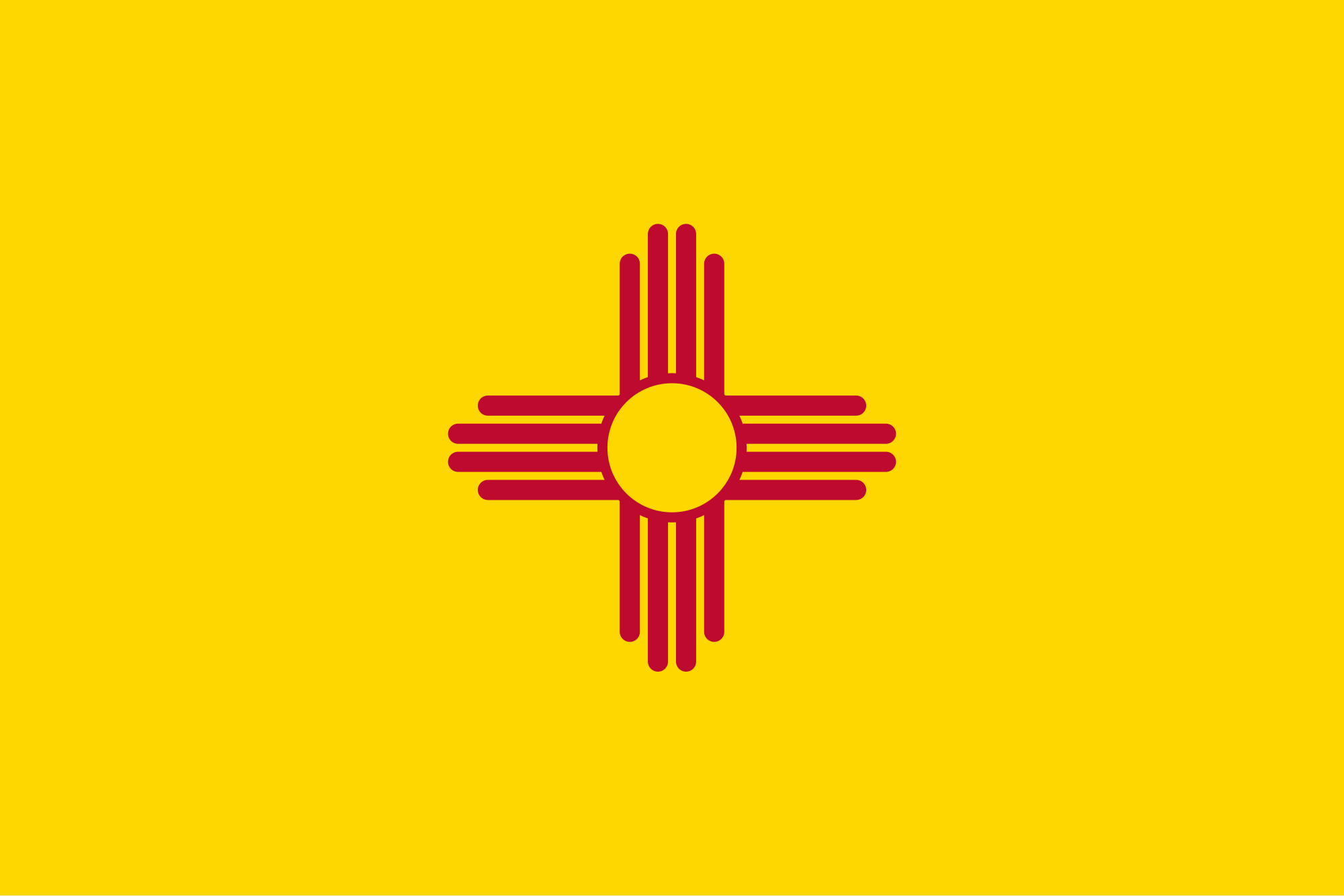
- State Flag and State Flag Information
- State Quarter
- State Bird
- State Seal
Elected Officials
New Mexico elected officials.
Activities
New Mexico Map and Quiz Printout
From Enchanted Learning.
Interactive Writing Tool {Free}
Create a state brochure using this interactive printing press.
Interactive Map Maker
Make and label your own map of New Mexico.
The U.S.: 50 States Map Quiz
Locate each state at Seterra.com.
20 Favorite New Mexican Foods
Cook up something the New Mexico way! Try this personal favorite.
Books
A Taste of New Mexico Kitchens
Cook up something the New Mexico way! Free eBook.

My State Notebook
From A Beka. “A basic guide to help students collect and learn the facts that are unique to their state as well as beginning research skills.”

Civics Activity Book
Also from A Beka, but written for a higher level than the above title, this activity book guides state research “in a study of national, state, and local government with a brief overview of the Constitution and a variety of interesting activity sheets. In addition to government, students also study the history, geography, and other characteristics of their state and local areas.” We have enjoyed many of the activities in this book, which include writing letters to state officials, researching the state history, and other activities.

State Birds and Flowers Coloring Book
Inexpensive option from Dover Publishing. Also check out their United States Coloring Book that has a state outline, symbols, and facts on one page.
Unit Studies & Lesson Plans
Smokey Bear: A Unit Study on Fire and Fire Safety
The real Smokey Bear was rescued in the mountains of New Mexico. Fun tie-in.
My State {Free Unit Study}
A recommended state study unit that covers civics, history, geography, language arts, applied math, science, and art, culminating in a personalized state notebook. We have also included additional go-along resources.
State History Outline & Projects
A wealth of original ideas and projects for making any state study a work of art!
Studying the 50 United States
Suggestions for a unit on any state from LearningTreasures.com.
Printables & Notebooking Pages
New Mexico State Maps for Notebook
- New Mexico State Map
- Road Map
- Population Map
- County Map
- Federal Lands and Indian Reservations
- Blank Outline Map
New Mexico State Facts Coloring Pages for Notebook
- State Flag Sheet
At Flags-to-Print.com. - State Bird & Flower Sheet
- State Flower Sheet
- State Bird Sheet
- State Coloring Page (Combined facts and symbols)
U.S. States and Capitals Map
Color New Mexico and write in the capital on this printable at PrintableMaps.net.
New Mexico Notebooking Pages
Simple pages for copywork, narrations, recording state facts, or wrapping up.
View all of our state unit studies:


You must be logged in to post a comment.